SAGA Metals Reports 8 Completed Drill Holes at Trapper North Aimed to Expand the MRE at the Radar Critical Minerals Project
Canada NewsWire
VANCOUVER, BC, Nov. 12, 2026
VANCOUVER, BC, Nov. 12, 2026 /CNW/ -- SAGA Metals Corp. ("SAGA" or the "Company") (TSXV: SAGA) (OTCQX: SAGMF) (FSE: 20H), a North American exploration company focused on critical mineral discoveries, is pleased to announce that continued NQ drilling at Trapper North on its Radar Titanium-Vanadium-Iron Project ("Radar" or the "Project") near Cartwright, Labrador is progressing on schedule with completion expected in the coming weeks. The program was designed to increase drill density and expand the geological and structural interpretation of Trapper North to aid in an expanded Mineral Resource Estimate ("MRE").
Highlights
- Oxide logged in every hole. Total logged oxide ranged from 48.8 m (R-0098) to 409.7 m (R-0094) per hole (Table 2). This brings the new total to 102/102 logged holes contain oxide mineralization. Logged lengths are visual observations, not grades; assays are pending.
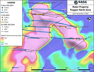
- Eight NQ holes completed. R-0093, R-0094, R-0095, R-0098, R-0099, R-0102, R-0103 and R-104 were drilled between September 19 and November 5th, 2026, for a total of 2,788 m (Table 1, Figure 1).
- Section spacing halved to 50 m. Three infill holes (R-0094, R-0095 and R-0099) were drilled on new intermediate sections N10A, N11A and N09A, each about 50 m from the neighbouring 100 m drill sections, reducing the section spacing and increasing drill density between sections N09 and N12.
- More data through the centre of the zone. Five holes (R-0093, R-0098, R-0102, R-0103 and R-0104) were drilled on existing sections N10, N09, N08 and N07 through the centre of the oxide zone as well as testing the deeper southwest limb of the Trapper North anticline to add geochemistry and structural data for modelling.
- Oriented core throughout. All core was oriented, so the attitudes of layering, contacts and structures can be measured to support the structural interpretation of Trapper North.
Michael Garagan, Chief Geological Office & Director of SAGA Metals commented:
"The MRE program, completed in August of this year, drilled Trapper North on 100-metre sections. After receiving all the assays and finalizing the geochemistry dataset, the team made the decision to immediately target the inferred sections in a follow up drill program with the goal of converting them to indicated. These eight completed drill holes add infill holes midway between three of the cross sections, while five additional holes targeted the centre of the zone, all in oriented core. That tightens our control on how the oxide layers connect from section to section and how the fold structure has modified the oxide layering. This structural data will be integrated into the geological model in order to expand the Mineral Resource Estimate."
NQ Infill and Section Drill Program
The infill program immediately followed the Company's 85-hole, 22,432-metre MRE drill program at the Trapper Zone, completed in August 2026. The initial drill program across the Trapper Zone focused on sections spaced 100 m apart. The infill program aimed to increase drill density and reinforce structural data by reducing section spacing to 50 m with three additional holes on new intermediate sections between existing cross sections. Five of the drill holes were drilled on existing sections through the centre of the oxide zone, as well as probed the deeper southwest limb of the anticlinal fold that was previously identified in Sections N10 and N11 (Table 1, Figure 1). The additional holes in this current program were drilled after the MRE drill database was closed and are not part of the maiden estimate being prepared by GeoGlobal LLC. This new dataset will be utilized in a follow up mineral resource estimate.
Table 1: NQ drill hole summary
Hole | Purpose | Section | Azimuth (°) | Dip (°) | Length (m) | Started | Completed |
R-0093 | Section | N10 | 40 | −55 | 380 | Sep 19 | Sep 24 |
R-0094 | Infill | N10A | 38 | −45 | 557 | Sep 24 | Oct 1 |
R-0095 | Infill | N11A | 37 | −46 | 401 | Oct 2 | Oct 5 |
R-0098 | Section | N09 | 218 | −45 | 272 | Oct 14 | Oct 17 |
R-0099 | Infill | N09A | 222 | −45 | 347 | Oct 18 | Oct 21 |
R-0102 | Section | N09 | 218 | -70 | 416 | Oct 27 | Oct 31 |
R-0103 | Section | N08 | 218 | -70 | 290 | Nov 2 | Nov 4 |
R-0104 | Section | N07 | 39 | -69 | 125 | Nov 5 | Nov 5 |
Total | 2788 |
Azimuth and dip are from the first downhole survey station. Lengths are drilled lengths. Started and completed dates are in 2026. Sections N09A, N10A and N11A lie midway between the existing 100 m sections.
All drill core from the program was oriented, as it allows the attitudes of magmatic layering, lithological contacts, foliation and faults to be measured directly. This structural data is vital to interpret the oxide layer continuity between sections and the how the oxide layering has been modified by faulting and folding.
Geological Logging
All completed infill drill holes to date intersected the semi-massive and rhythmic (intercumulate) oxide gabbronorite units that host the titanomagnetite and ilmenite mineralization at Radar (Table 2). The oxide intervals in these infill holes ranges from 48.8 m in R-0098, on section N09, to 409.7 m in R-0094, on intermediate section N10A.
Table 2: Logged oxide in the NQ holes
Hole | Section | Length (m) | Oxide from–to (m) | Semi-massive oxide (m) | Rhythmic / intercumulate oxide (m) | Total logged oxide (m) |
R-0093 | N10 | 380 | 59.8–187.9 | 112.4 | 9.7 | 122.1 |
R-0094 | N10A | 557 | 46.7–521.0 | 238.3 | 171.4 | 409.7 |
R-0095 | N11A | 401 | 48.6–350.0 | 163.7 | 20.8 | 184.5 |
R-0098 | N09 | 272 | 2.3–51.1 | 43.5 | 5.4 | 48.8 |
R-0099 | N09A | 374 | 43.0–340.7 | 110.5 | 79.7 | 190.1 |
R-0102 | N09 | 416 | 74.8-401.2 | 59.6 | 202.7 | 262.3 |
R-0103 | N08 | 290 | Logging in Progress | |||
R-0104 | N07 | 125 | Logging in Progress |
Logged oxide lengths are downhole core lengths of visually logged oxide units; "from–to" spans the first and last logged oxide unit and includes internal non-oxide units. Logged lengths are not estimates of grade or of true thickness, and visual observations are not a substitute for laboratory analysis. True thicknesses have not yet been estimated. Totals may not sum because of rounding. Assays are pending.
Next Steps
- Complete remainder of the planned holes within the defined drill program.
- Complete sampling of the NQ holes and submit to IGS.
- Report assays when received over the coming weeks.
- Integrate the logging, structural measurements and assays into the geological model of Trapper North.
- Complete expanded MRE for the Trapper Zone.
About the Radar Critical Mineral Property in Labrador
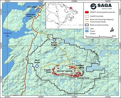
The Radar Property comprises 690 mineral claims across 9 mineral licenses, totalling approximately 24,175 hectares in southeastern Labrador, located approximately 10 km south of Cartwright. The Property entirely encloses the Dykes River Intrusive Complex (~160 km² at the surface) and is accessible year-round via paved Route 510, a Cartwright logging road, and a SAGA-constructed access trail. Infrastructure advantages include the deep-water port at Cartwright, the Cartwright Airport (YRF), and proximity to regional hydroelectric power from Muskrat Falls and Churchill Falls.
Diamond drilling, geophysics, trenching and geological mapping have confirmed a 29 km2 oxide-bearing lopolith that host the Trapper, Falcon and Hawkeye Zones. VTM mineralization at Radar is comparable to that of global Fe-Ti-V systems such as Panzhihua (China) and Bushveld (South Africa). Subject to further exploration, resource definition, and metallurgical testing, the Project may represent a strategic source of titanium, vanadium, and iron for North American markets.
Qualified Person
Dr. A. Miller, PGO, PEGNL, is an Independent Qualified Person as defined under National Instrument 43-101 and has reviewed and approved the technical information disclosed in this news release.
Technical Information
Drill core from the program is NQ diameter (47.6 mm). All core from the program was oriented. Core is logged and sampled by Company personnel at SAGA's core facility in Cartwright, Labrador. The core was cut lengthwise using a diamond saw, and one half was retained in the core box, while the other half was sampled at designated intervals for analysis and will be further concentrated for metallurgical test work. Samples for assay are prepared and analysed by Impact Global Solutions Inc. ("IGS") in Québec, a laboratory independent of the Company, by lithium-borate fusion with X-ray fluorescence finish. Certified reference materials, coarse blanks, and coarse and pulp duplicates are inserted into the sample stream at regular intervals. Crush rejects and pulps are retained in secure storage.
Semi-massive oxide and rhythmic (intercumulate) oxide are lithological units logged visually from the abundance and texture of oxide minerals. Logged lengths are downhole core lengths.
About SAGA Metals Corp.
SAGA Metals Corp. is a North American mining company focused on the exploration and discovery of a diversified suite of critical minerals that support the North American transition to supply security. The 100% owned Radar Ti-V-Fe Project comprises 24,175 hectares and entirely encloses the Dykes River intrusive complex, mapped at 160 km² on the surface near Cartwright, Labrador. Exploration to date, including 28,439 m of drilling in the Hawkeye and Trapper zones, has confirmed a large, mineralized layered mafic intrusion hosting vanadiferous titanomagnetite (VTM) and ilmenite mineralization with consistently uniform grades of titanium, vanadium and iron.
The 100% owned Wolverine Heavy Rare Earth Element Project in Labrador, is a near-surface REE system hosted within peralkaline volcanic rocks that shares petrological similarities with the intrusion-hosted Tanbreez, Strange Lake deposits and the stratiform Brockman (Hastings) REE deposit, Western Australia. Historic drilling on the Wolverine prospect identified consistent mineralization with assays up to 2.03% TREO including approximately 28% HREO. Large scale potential is supported by 26 km2 of exposed mineralization tuff at surface with about 5% of the prospective unit drilled to date. In addition, grab sample assays of pegmatite hosted in peralkaline granite returned up to 21.6% TREO.
The 100% owned Double Mer Uranium Project covers 25,600 hectares and features uranium radiometrics that highlight an 18 km east-west trend, with a confirmed 14 km section producing samples as high as 0.428% U3O8. (2024 Double Mer Technical Report).
Additionally, SAGA owns the Legacy Lithium Project in Quebec's Eeyou Istchee James Bay region. This project spans 73,866 hectares and has geological attributes similar to nearby terrains currently being explored by Rio Tinto, Li-FT Power, SOQUEM, and Loyal Metals.
With a portfolio spanning key commodities critical to the clean energy future, SAGA is strategically positioned to play an essential role in securing critical minerals.
On Behalf of the Board of Directors
Mike Stier, Chief Executive Officer
Neither the TSX Venture Exchange nor its Regulation Service Provider (as that term is defined in the policies of the TSX Venture Exchange) accepts responsibility for the adequacy or accuracy of this release.
Cautionary Disclaimer
This news release contains forward-looking statements within the meaning of applicable securities laws that are not historical facts. Forward-looking statements are often identified by terms such as "will", "may", "should", "anticipates", "expects", "believes", and similar expressions or the negative of these words or other comparable terminology. All statements other than statements of historical fact, included in this release are forward-looking statements that involve risks and uncertainties. In particular, this news release contains forward-looking information pertaining to the Company's plans and objectives related to its Radar Project. There can be no assurance that such statements will prove to be accurate, and actual results and future events could differ materially from those anticipated in such statements. Important factors that could cause actual results to differ materially from the Company's expectations include, but are not limited to, changes in the state of equity and debt markets, fluctuations in commodity prices, delays in obtaining required regulatory or governmental approvals, environmental risks, limitations on insurance coverage, inherent risks and uncertainties involved in the mineral exploration and development industry, particularly given the early-stage nature of the Company's assets, and the risks detailed in the Company's continuous disclosure filings with securities regulations from time to time, available under its SEDAR+ profile at www.sedarplus.ca. The reader is cautioned that assumptions used in the preparation of any forward-looking information may prove to be incorrect. Events or circumstances may cause actual results to differ materially from those predicted, as a result of numerous known and unknown risks, uncertainties, and other factors, many of which are beyond the control of the Company. The reader is cautioned not to place undue reliance on any forward-looking information. Such information, although considered reasonable by management at the time of preparation, may prove to be incorrect and actual results may differ materially from those anticipated. This cautionary statement expressly qualifies forward-looking statements contained in this news release. The forward-looking statements contained in this news release are made as of the date of this news release, and the Company will update or revise publicly any of the included forward-looking statements only as expressly required by applicable law.

 View original content to download multimedia:https://www.prnewswire.com/news-releases/saga-metals-reports-8-completed-drill-holes-at-trapper-north-aimed-to-expand-the-mre-at-the-radar-critical-minerals-project-302938054.html
SOURCE SAGA Metals Corp.

